
Madison County Schools cancel Monday classes due to Hurricane Ida impact

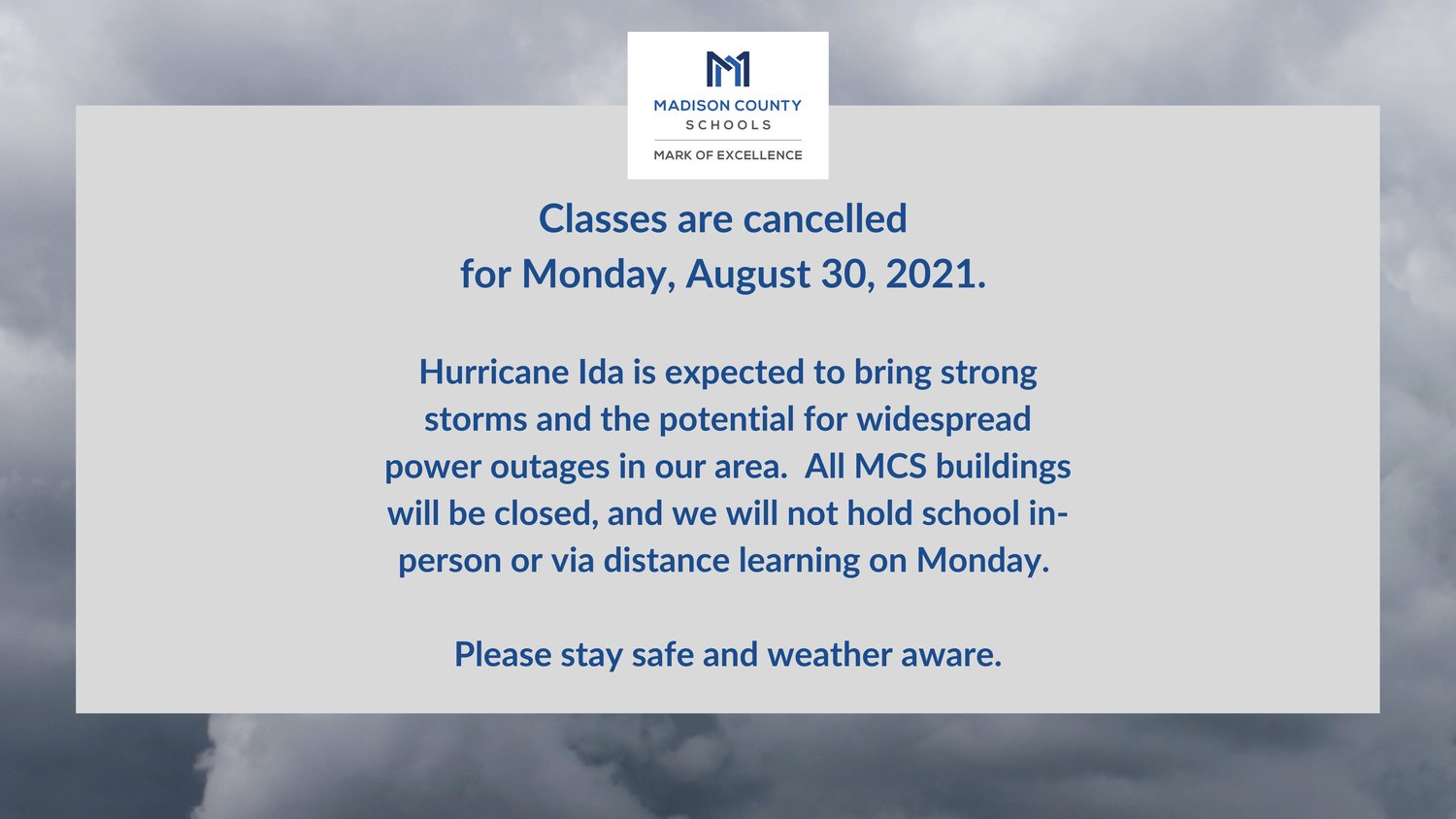

Madison County Schools have canceled classes for Monday, Aug. 30, due to projected storm impact from Hurricane Ida that will bring heavy winds and rains through central Mississippi Monday.
Central Mississippi, including Madison County, is under a tropical storm warning as of Sunday morning with Hurricane Ida expected to bring rains and winds through the area as early as tonight (Sunday) and through Monday night, the National Weather Service of Jackson is projecting.
“All MCS buildings will be closed, and we will not hold school in-person or via distance learning on Monday,” a Madison County Schools statement released Saturday night states. “Please stay safe and weather aware.”
Hurricane Ida made landfall just before noon Sunday near Grand Isle, Louisiana, as a category 4 storm before moving inland and will bring with it heavy rains and winds through central Louisiana and Mississippi.
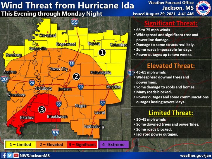
“The greatest impacts will occur across southwestern Mississippi and central Louisiana, where gusts to near hurricane force are possible,” a Sunday morning forecast from the NWS of Jackson states. “Widespread tree and utility damage is expected, which may result in power outages that last for several days. Tropical storm force winds are also expected farther north across Central Mississippi, Northeast Louisiana, and Southeast Arkansas with numerous power outages expected in those areas as well.”
Madison Mayor Mary Hawkins said city crews will be prepared to work in affected areas as soon as the storm passes through.
“By the time the storm approaches the Madison area, winds should be sustained 45-65 mph from 2 a.m. Monday morning till 4 p.m. Monday afternoon,” Hawkins said early Sunday afternoon citing the latest NWS report. “This may cause trees and power lines to fall. Four to 8-inches of rain is projected for our area. This is one of the strongest storms to ever make landfall along the coast region. Stay away from downed trees and power lines. Stay off roads Monday if you do not need to travel. City crews will be in any affected areas of the city as soon as possible.”
Waste Management announced Sunday that it will not provide garbage collection services on Monday due to the anticipated severe weather impacts associated with Hurricane Ida.
“Waste Management has canceled all collection services for its valued customers in the City of Jackson and surrounding counties for Monday, Aug. 30, 2021,” Waste Management states. “Weather and safe road conditions permitting, service will resume as follows: Commercial customers will experience a one-day delay in service. Residential customers who are collected twice a week will be serviced on their next regularly scheduled collection day. Residential customers in the following areas, who are serviced once a week, will experience a one-day delay in service: Madison County, Copiah County including Wesson, Hinds County, City of Canton, City of Madison recycling customers will be serviced on their next regularly scheduled collection day. All customers affected in the area are encouraged to visit https://www.wm.com/weather-alert/index.jsp for additional information about impacted service routes.”
Sunday’s forecast calls for showers and possibly a thunderstorm, mainly after 1 p.m.
“Some of the storms could produce heavy rainfall,” NWS states. “High near 89. Heat index values as high as 103. East wind 10 to 15 mph, with gusts as high as 30 mph. Chance of precipitation is 80%. New rainfall amounts of less than a tenth of an inch, except higher amounts possible in thunderstorms.”
Entergy, central Mississippi’s main electrical provider said they are prepared to repair any outages as soon as possible and advised people with disabilities or caretakers to contact their support network before severe weather strikes.
“Consider informing someone you trust about where you keep your emergency supplies and provide them a spare key in case of an emergency,” Entergy states in a press release. “We're ready for stormy weather and have our response plans in place. We encourage you to finalize your plans, too.”
Tonight (Sunday night), in Madison County tropical storm conditions are possible with showers likely before 1 a.m., then rain between 1 a.m. and 4 a.m., then showers after 4 a.m.
“The rain could be heavy at times,” the NWS states. “Low around 73. Chance of precipitation is 100%. New precipitation amounts between a half and three quarters of an inch possible.”
Tropical storm conditions expected are expected in Madison County on Monday. Showers, with thunderstorms also are possible after 1 p.m.
“Some of the storms could produce heavy rainfall,” the NWS states. “High near 77. Chance of precipitation is 100%. New rainfall amounts between 3 and 4 inches are possible.”
Monday night, Madison County will experience rain and possibly a thunderstorm before 1 a.m., then rain likely.
“Some of the storms could produce heavy rainfall,” the NWS states. “Low around 72. Windy, with a southwest wind 25 to 35 mph decreasing to 15 to 25 mph after midnight. Winds could gust as high as 55 mph. Chance of precipitation is 80%. New rainfall amounts between 1 and 2 inches possible.”
The chance of showers and thunderstorms in Madison County falls to 20% on Tuesday when it will be partly sunny, with a high near 86. West southwest wind 10 to 15 mph, with gusts as high as 25 mph.
Entergy’s Checklists for Tropical Storms
Make a Plan
There are many things to consider when making your family emergency plan. Sit down with your family and decide how you'll contact each other, where you'll go for safety and what you'll do during and after the storm.
Things to discuss:
Designate one or more out-of-town contacts. These people may be reached more easily and can relay messages to your family members if you become separated during or after the storm. Check with your emergency contacts beforehand to make sure they are willing and able to assist you in an emergency.
Important phone numbers. Be sure every member of your family knows the phone numbers to call your emergency contacts. If you have a cellphone for each family member, program your emergency contacts’ phone numbers in as “ICE” (In Case of Emergency). Emergency personnel often check your ICE listings in order to reach someone you know. Make sure to tell your family and friends that you’ve listed them as emergency contacts.
Learn to text message. Often times a text message can get around network disruptions when voice communications cannot. Knowing how to send and receive text messages can be an important way to communicate with loved ones. Check out other tips for preparing your mobile phone for a crisis event.
Decide to stay or go. Before the storm approaches, decide whether you'll stay where you are or evacuate. You should understand and plan for both possibilities. If you evacuate, you may need several possible destinations to travel to depending on where the storm is headed and should plan accordingly.
A mandatory evacuation is just that– mandatory. However, use common sense in reaching your decision. Remember in an emergency, local authorities may or may not immediately be able to provide information on what's happening and what you should do. Radio, TV and the internet may provide you with official information as it becomes available to help you decide if there is an immediate danger.
Know the plan at work or school. Find out about emergency plans at places where your family spends time: work, day care and school. If there are no plans, then consider volunteering to help create one.
Make a Kit
After a storm passes, it likely will be some time before things return to normal. It could be hours or days. You may have to fend for yourself and your family until help arrives. The best way to accomplish that is to have a kit ready containing the basic supplies you’ll need in an emergency. You can find lists from many sources to help you make your kit, including ready.gov and the American Red Cross. In general, experts agree your kit could include:
Water, one gallon of water per person per day for at least three days, for drinking and sanitation.
Battery-powered or hand-crank radio and a National Oceanic and Atmospheric Administration Weather Radio with tone alert and extra batteries for both.
Cellphone with charger, inverter or solar charger.
Flashlight and extra batteries.
First aid kit with emergency reference material, such as a first aid book.
Complete change of clothing including a long-sleeved shirt, long pants and sturdy shoes. Consider additional clothing if you live in a cold-weather climate.
Sleeping bag or warm blanket for each person. Consider additional bedding if you live in a cold-weather climate.
Important family documents such as copies of insurance policies, identification and bank account records in a waterproof, portable container.
Moist towelettes, garbage bags and plastic ties for personal sanitation.
Personal hygiene items including feminine supplies.
Matches in a waterproof container.
Paper towels, paper cups, plates and plastic utensils or mess kits.
Cash or traveler’s checks and change.
Paper and pencil.
Wrench or pliers to turn off utilities.
Whistle to signal for help.
Dust mask, to help filter contaminated air and plastic sheeting and duct tape to shelter-in-place.
Household chlorine bleach and medicine dropper. When diluted nine parts water to one part bleach, bleach can be used as a disinfectant. Or in an emergency, you can use it to treat water by using 16 drops of regular household liquid bleach per gallon of water. Do not use scented, color safe or bleaches with added cleaners.
Fire extinguisher.
Local maps.
Prescription medications and glasses.
Infant formula and diapers.
Pet food and extra water for your pet.
Books, games, puzzles or other activities for children.