
Central Mississippi could get heavy rain, wind next week from Hurricane Ida
Hurricane Ida is projected to make landfall along the northern Gulf Coast Sunday before moving inland and bringing heavy winds and rain likely through central Mississippi early next week.
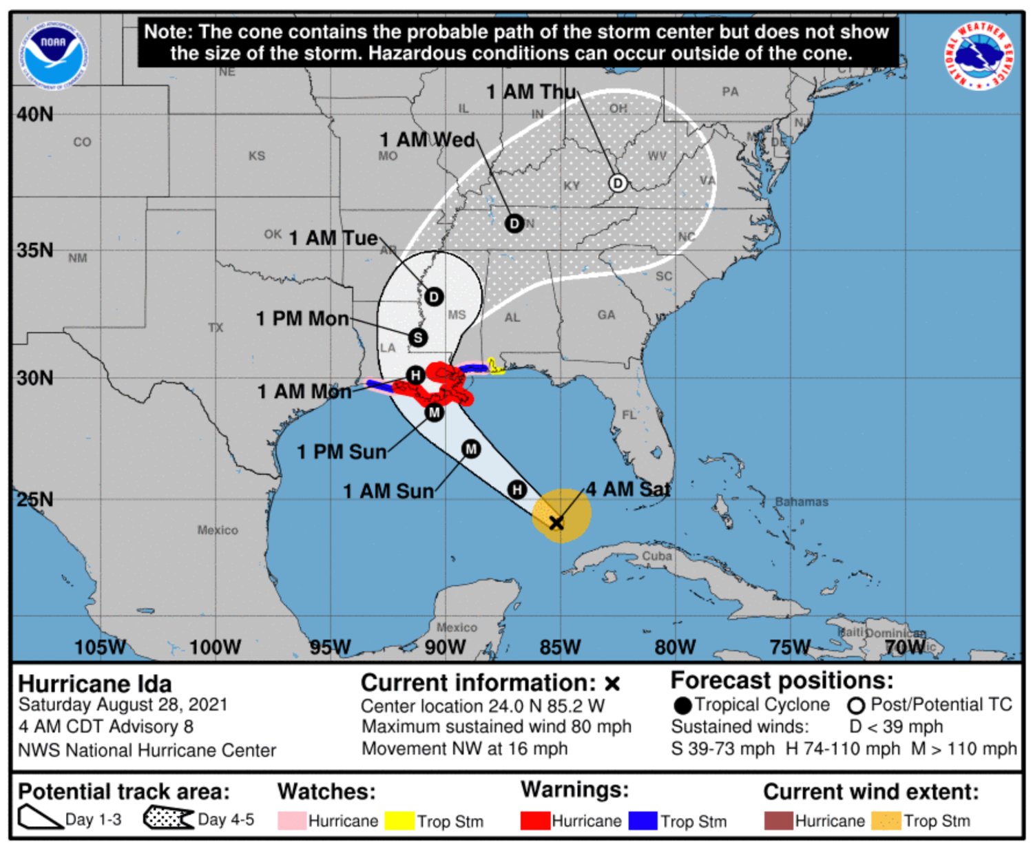
The National Weather Service upgraded Tropical Storm Ida to a Category 1 Hurricane on Friday afternoon as the storm passed over the Isle of Youth and was expected to move over the southeastern and central Gulf of Mexico Friday night and Saturday.
Ida is forecast to make landfall along the U.S. northern Gulf Coast between Texas and Georgia sometime Sunday morning, which is the 16th anniversary of the day Hurricane Katrina made landfall near Pearlington near the Mississippi-Louisiana state line on Aug. 29, 2005.
One likely path of Hurricane Ida shows it making landfall in Louisiana near the Mississippi state line and advancing up into central Mississippi through Tuesday bringing with it heavy rain, strong winds and flash flooding, according to a 7:15 a.m. forecast issued by the National Weather Service in Jackson.
“This forecast is subject to change, so please check back for updates,” the NWS Jackson office states in the press release via Twitter @NWSJacksonMS.
The National Hurricane Center is predicting a dangerous storm surge in the projected landfall area along the northern Gulf Coast.
“The water could reach the following heights above ground somewhere in the indicated areas if the peak surge occurs at the time of high tide: Morgan City, LA to Ocean Springs, MS including Lake Borgne...7-11 ft; Rockefeller Wildlife Refuge, LA to Morgan City, LA including Vermilion Bay...4-7 ft; Ocean Springs, MS to MS/AL border...4-7 ft; MS/AL border to AL/FL border including Mobile Bay...3-5 ft; Lake Pontchartrain...4-6 ft Lake Maurepas...3-5 ft; Sabine Pass to Rockefeller Wildlife Refuge, LA...2-4 ft.”
As the storm moves inland it is expected to bring heavy rainfall, the NHC states.
“As Ida approaches the central Gulf Coast Sunday afternoon, total rainfall accumulations of 8 to 16 inches with isolated maximum amounts of 20 inches are possible from southeast Louisiana to coastal Mississippi and Alabama through Monday morning. Ida is forecast to turn northeast as it moves inland later Monday with rainfall totals of 4 to 8 inches possible across southern and central Mississippi. This is likely to result in considerable flash, urban, small stream and riverine flooding.”